California Highways (www.cahighways.org): County Route J14

Stanislaus/Calaveras
County Sign Route J14
[Click here for a key to the symbols used. Some county routes were constructed with federal funds. These routes are indicated as FAP (Federal Aid Primary), FAU (Federal Aid Urban), or FAS (Federal Aid Secondary). If no funding source is shown, no federal funds were used. Note that while some segments seem to have the same attributes, they may differ in the county-local road number assigned to the segment, or in the Caltrans Map Sheet number.]
 Routing
-
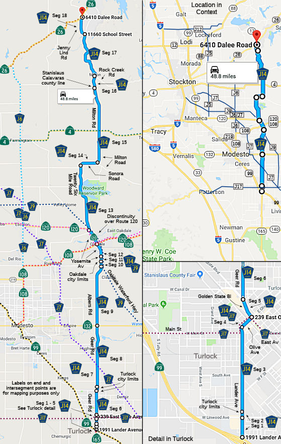 Lander Avenue in Turlock from Route 99 to Linwood Avenue (FAU, 0.26 mi) [Stanislaus
County]
Lander Avenue in Turlock from Route 99 to Linwood Avenue (FAU, 0.26 mi) [Stanislaus
County] -
Lander Avenue from Linwood Avenue to the Turlock city limits (FAU, 0.25 mi) [Stanislaus County]
-
Lander Avenue in Turlock from the Turlock city limits to W Olive Street (FAU, 0.77 mi) [Stanislaus County]
-
Olive Street in Turlock from Lander Avenue to Golden State Blvd (FAU, 0.18 mi) [Stanislaus County]
-
Golden State Blvd in Turlock from Olive Street to Geer Road (FAU, 0.25 mi) [Stanislaus County]
-
Geer Road in Turlock from Golden State Blvd to the Turlock city limits (FAU, 1.77 mi) [Stanislaus County]
-
Geer Road outside the Turlock city limits from the Turlock city limits to the Turlock city limits (FAU, 0.23 mi) [Stanislaus County]
-
Geer Road from the Turlock city limits to Route 132 near Empire (FAS, 7.61 mi) [Stanislaus County]
-
Albers Road from Route 132 to the Oakdale Waterford Highway (FAS, 7.06 mi) [Stanislaus County]
-
Albers Road from Oakdale Waterford Highway to the Oakdale city limits (FAS, 0.81 mi) [Stanislaus County]
-
Alberts Road in Oakdale from the Oakdale city limits to Yosemite Avenue (0.57 mi) [Stanislaus County]
-
Yosemite Avenue in Oakdale from Alberts Road to Route 120 (0.76 mi) [Stanislaus County]
-
Twenty Six Mile Road from Route 120 to Sonora Road (7.69 mi) [Stanislaus County]
-
Sonora Road from Twenty Six Mile Road to Milton Road (1.84 mi) [Stanislaus County]
-
Milton Road from Sonora Road to the Calaveras county line (8.60 mi) [Stanislaus County]
-
Milton Road from the Stanislaus county line to Rock Creek Road (1.35 mi) [Calaveras County]
-
Milton Road from Rock Creek Road to Jenny Lind Road (FAS, 6.30 mi) [Calaveras County]
-
Jenny Lind Road from Milton Road to Route 26 (1.61 mi) [Calaveras County]
 History and Signage Information
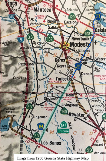 This route appears to
have been defined in 1964-1966, with an additional segment that ran from
Turlock to Los Banos along what is now Route 165. In 1970, Chapter 1473
redefined Route 165 to "Route 5 south of Los Banos to Route 99 near
Turlock.". The remainder of the route remained as County Sign Route J14. This is shown on
the 1966 Gousha Map.
This route appears to
have been defined in 1964-1966, with an additional segment that ran from
Turlock to Los Banos along what is now Route 165. In 1970, Chapter 1473
redefined Route 165 to "Route 5 south of Los Banos to Route 99 near
Turlock.". The remainder of the route remained as County Sign Route J14. This is shown on
the 1966 Gousha Map.
(Supporting Source and Hat Tip: Gribblenation Blog
"California State Route 162 to the Bidwell Bar Bridge (both the 1965 and 1856 variants)")
County Sign Route J14 south of Route 99 in Turlock to Route 152/Route 33 in Los Banos
was spun off into the second designation of Route 165 by way of 1970
Legislative Chapter 1473. The second Route 165 was defined as a
38-mile highway between Route 99 in Turlock to I-5 approximately 9 miles
south of Los Banos. The creation of the second Route 165 aligns with
the opening of I-5 in the Los Banos area. Route 165 seemingly was
designated to permit access from a State maintained facility in Los Banos
to both I-5 and Route 99. It is not clear if County Sign Route J14 ever reached I-5
when freeway opened south of Los Banos. As of 1975, the unbuilt
segment of Route 165 between Stevinson to Turlock likely was not up to
State standards and probably was signed as County Sign Route J14. By 1979, Route 165 was completed to Turlock. It was likely at this point that County Sign Route J14 was truncated to Route 99.
(Source: Gribblenation Blog (Tom Fearer), "Stanislaus-Calaveras County Route J14", September 2022)
 Other WWW Links
 Status
Total mileage: 47.91 mi. The segment on Olive Street in Turlock is cosigned with County Sign Route J17. The segment from Albers Road and Oakdale Waterford Highway and Route 120 is cosigned with County Sign Route J9.
- "LRN" refers to the Pre-1964 Legislative Route Number. "US" refers to a US Shield signed route. "I" refers to an Eisenhower Interstate signed route. "Route" usually indicates a state shield signed route, but said route may be signed as US or I.
- Previous Federal Aid (pre-1992) categories: Federal Aid Interstate (FAI); Federal Aid Primary (FAP); Federal Aid Urban (FAU); and Federal Aid Secondary (FAS). Current Functional Classifications (used for aid purposes): Principal Arterial (PA); Minor Arterial (MA); Collector (Col); Rural Minor Collector/Local Road (RMC/LR). Note that ISTEA repealed the previous Federal-Aid System, effective in 1992, and established the functional classification system for all public roads.
- Other frequently used terms: California Transportation Commission (Commission or CTC), California Department of Transportation (Department or Caltrans), Regional Improvement Program (RIP), Interregional Improvement Program (IIP), State Transportation Improvement Program (STIP), State Highway Operation and Protection Program (SHOPP), Traffic Congestion Relief Program (TCRP), Clean Air and Transportation Improvement Act of 1990 (Proposition 116), High Speed Passenger Train Bond Program (Proposition 1A), Highway Safety, Traffic Reduction, Air Quality, and Port Security Bond Act of 2006 (Proposition 1B), Corridor Mobility Improvement Account (CMIA), State Route 99 Bond Program (RTE or SR 99), Local Bridge Seismic Retrofit Account (LBSRA), Trade Corridors Improvement Fund (TCIF), Highway-Railroad Crossing Safety Account (HRCSA), State-Local Partnership Program (SLPP), Environmental Phase (PA&ED), Design Phase (PS&E), Right of Way (R/W), Fiscal Year (FY), Active Transportation Program (ATP), Trade Corridor Enhancement Program (TCEP), Local Partnership Program (LPP), Local Streets and Roads Program (LSRP), Solutions for Congested Corridors Program (SCCP).
 CR J13
 CR J15
© 1996-2024 Daniel P. Faigin.
Maintained by: Daniel P. Faigin
<webmaster@cahighways.org>.